
| Intro 1998 1999 | Page 1 - 2 - 3 |
|
Map 7 - The Olvidado Group
The Olvidado Group is a small group of structures arranged around the well-known Olvidado Temple. The Olvidado Temple was first recorded by Blom in the 1920's and excavated by Berlin in the 1940's. Including the Olvidado Temple, there are ten structures and four wide platforms in the group. Thirty meters to the east of the Olvidado Temple lies a large platform identified by Blom as "Group I". The Group I platform was built into the hillside and has two small structures on top. The eastern of those two structures, O1, has a collapse hole on its top revealing a chamber some two meters down, inside the large platform. Blom's report (1926) records that a burial chamber was found there.
Generally speaking, the Olvidado Group does not appear to be residential. The Group I platform and the Olvidado Temple seem too visible to have functioned as private quarters. The smaller associated structures, especially the low terraces, seem to be supporting architecture rather than private spaces. None of the patios or courtyards typically associated with residential activities were found in the Olvidado Group. The next section, discussing the Picota Group, will discuss a connection between the Olvidado and Picota Groups.
Map 8 - The Picota Group
The Picota Group includes a diverse collection of structures, both public and residential. Its boundaries, with the exception of its western section, were drawn by the use of watercourses as borders. There are a total of sixty-seven structures and eight small courtyards within the Picota Group. Exposed architecture exists on the surfaces of structures P3, 5, 12, 26, 37 and 61. No looter's pits were found in direct contact with the structures of the Picota Group but one pit was dug into the terrace directly in front of structure P37. The structures and features encountered within the group differed from those recorded in previous maps to such an extent that, besides the Picota's stela and aqueduct, the PMP map presents entirely new information. The heart of the Picota Group is the irregularly shaped Picota Plaza. The irregular shape is caused by the protrusion of structures P23, 24 and 25 into the plaza, creating two distinct sections of plaza space. The western part of the plaza contains the La Picota Stela (the feature for which the area is named), the Picota aqueduct, and a well-preserved staircase climbing nine steps up from its southern boundary. Towering above the Picota Plaza to the south are a series of three terraces topped by structure P14 and its associated courtyard group. Structure P12, located five meters to the southeast of P14 has an area of collapse in its top revealing a subterranean tomb chamber below. In form and geographic placement, the line of temple-like structures running from the structure P14 eastward to the Group I platform are reminiscent of the line of structures in Palenque's primary center created by Temple XII, XIII and the Inscriptions. Both areas have temples built into the hillside overlooking a plaza. Acknowledging that XII, XIII and the Inscriptions are funerary monuments, a similar function is suspected for these southern temples of the Picota Group. Collectively, the presence of a large plaza, a stela, an elaborate aqueduct and a line of funerary temples along the south edge give the Picota area a distinctly "central precinct" character. The large nearby structure designated the Escondido Platform further supports that conclusion. Palenque appears to have had not one, but two "centers". The Picota Group's northern section is more residential in character, comprised of smaller buildings arranged around courtyards and open patio spaces. Though included spatially as part of the Picota Group, this area of residential settlement also seems associated with the Lemon Group's settlement just to the east.
The water management of the Picota Group is arguably Palenque's most sophisticated example. The aqueduct is built of tightly fitted stones and fed by multiple springs. Its state of preservation is superior to that of the aqueduct in Palenque's central precinct. With the exception of a few capstones that have fallen in, the Picota aqueduct is completely intact and functional. As the water spills from the aqueduct's exit, it forms the watercourse known as the Picota River. The course of this river turns sharply to the east, passing through the Lemon and Nauyaka residential zones, and ultimately joining the Piedras Bolas River via a wide area of shallow cascades. The fact that the Picota, unlike Palenque's other rivers, does not follow gravity and flow straight north towards the floodplains below strongly suggests its course was altered to flow through the residential areas.
Map 9 - The Nauyaka and Lemon Groups
The Lemon Group sits on almost completely flat land along the southern side of the Picota River. The vegetation surrounding the group is extremely dense as a result of its former use as cattleland. The group's name comes from the presence of many lemon (not lime) trees sporadically found within its boundaries. Since they are not indigenous to the area, it is assumed they were planted by the former landowner. The groups named Hochol Bi' and Atotob in the Robertson map could not be clearly identified but were probably found within what is now defined as the Lemon Group. There are eighty structures and fifteen residential courtyards within the group, most of which were built along the southern bank of the Picota River. The majority of the group's structures are small and tightly clustered. Architecture exposed at the surface was documented on structures L4 and 7.
The single looter's pit of the Lemon Group is located one meter north of structure L10. The group's largest structure, L67, was found less than ten meters from the main footpath through the area. Though the structure is over four meters in height and thirty meters long, the dense vegetation covering it had completely hidden it from view. Unlike other groups found in Palenque's western region, the Lemon Group appears to have a large open plaza in its center, linking all the individual courtyard groups to one communal space. There seems to have been a communal agreement to leave the area free of buildings.
Map 9 - The Nauyaka and Lemon Groups
Except for its very northern end, the Nauyaka Group sits on flat land. It is bounded on the south by the Picota River and on the north by a steep hillside, as yet unrecorded by the PMP. Like the Lemon Group, many of its structures line the Picota River. The inspiration for the group's name came from the large number of poisonous snakes encountered within its boundaries, five in the course of two weeks. Nauyaka is the local name for the snake more commonly called the Fer-de-Lance. A total of seventy-four structures and seventeen courtyards were found within the Nauyaka Group. In a pattern not seen in other sections of Palenque, most of the residential groups in this area are connected by elevated platforms. The looting evidence in the Nauyaka Group is by far the worst the PMP has encountered in Palenque. A total of eighteen looter's pits were found, primarily in the groups on elevated platforms. Looted structures include structures N26, 29, 43, 45, 46, 47, 65 and 70. The very thick vegetation of the area combined with the noise of nearby rushing water made it a perfect area for clandestine looting. Evidence around the pits in structure N25 indicates the looting is relatively recent. Coke cans, chip bags and cigarette packs were found lying about still in good condition, as yet unaffected by the fast-acting elements of a rain forest environment.
Structure N70 has an uniquely triangular form. A terrace on the other side of the Picota also has a side of odd orientation, mirroring N70's riverside wall. The two structures together seem to bracket the Picota's end as it falls into the Piedras Bolas River. Sitting in the Picota River next to structure N11 lies an interesting water management feature of indeterminate function. Though partially destroyed, it appears to be similar to the feature in the Motiepa River next to the Encantado Temple. It is a stone slab constructed box that has openings on either side through which water can pass. The similar Motiepa example was loosely termed an aqueduct in the Robertson map.
Map 10 - The Escondido Group
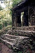
The Escondido Group is arranged around a massive platform presented for the first time in this report. The name "Escondido" was chosen to denote the platform's amazingly hidden status until now. Most of the group's sixty structures, though associated with the Escondido Platform, are arranged around residential-type courtyards. Almost all structures on its east side are arranged in small courtyard groups. Looter's pits were encountered in structures ED15, 37, 38 and 46. Exposed architecture exists on structures ED15, 36 and 57. The Escondido Group as a whole was built on flat ground with a commanding northern view of the plains below. The view from the Escondido Platform is one of the most far-reaching in all of Palenque. The Escondido Platform itself measures 80x140m at its base, making it slightly larger than Palenque's Palace (Figure 1). Though no surface evidence indicates entrances into the platform itself, Palenque's predilection towards subterranean chambers suggests the presence of internal rooms and passageways. The structures encountered on top of the Escondido Platform are humble and arranged much in the way of typical residential patio groups. Structure ED15 is the largest structure on top of the platform. It is "L" shaped and has a stone feature on top that appears most like a destroyed bench. A partially intact stairway steps down off ED15's eastern side patio. Lower platforms supporting smaller structures extend off the Escondido's north, south and east sides. To the west is an arroyo and cleared, presently inhabited hills. To the north, platforms step downhill twice before ending at the edge of a sheer cliff dropping off over fifty meters to the plains below. The southern platform is a single construction with eight small structures on top. The majority of the structures in the Escondido Group lie to the east of the large platform. The modern structure located off the southwest corner of the Escondido Platform was built on the property of Don Heber, a INAH employed guard of the ruins. The structure is the home of the land's caretakers, a man named Cristobal and his family. Don Heber also owns the milpa growing on top of the Escondido Platform. First, the ceramic sequence defined by Dr. Robert Rands has identified specimens from the Picota area as some of the oldest at the site (p.c.). Second, data points collected in the Picota Plaza were found to be less than 50cm (on average) in elevation difference from those recorded in the plaza surrounding Palenque's Palace. The central complex of Moises' Retreat, though located along the same central plateau as the two big plazas, sits at an elevation seventeen meters lower. If the identical elevation of the two, almost one kilometer apart plazas is not a coincidence then one must have patterned itself upon the other. Two facts combine to point to the central plaza as the emulator. One, the Picota Plaza slopes very gently down to the river that defines its northern boundary. Since the river is shallow and at essentially plaza level, we can assume the Picota Plaza was neither built up nor dug down to any large extent. In contrast, Palenque's central plaza sits upon a terrace, built up as much as four meters in places. Clearly, if one plaza emulated the other, the smaller Picota Plaza was the original.
The discovery of this second center at Palenque leads to a hypothesis with potential to answer a growing question regarding the members of Palenque's early royal lineage. Despite decades of excavation in Palenque's central precinct, archaeologists have found little evidence of royal family activities earlier than the time of Pakal. The exceptions, the XVIIIa tomb (Berlin 1943) and the Reyna Roja (Gonzalez Cruz 1998), are still under debate as to the antiquity of their time periods. David Stuart has read Palenque hieroglyphic texts referring to a place named "Tok Tan" as the origin place of the Palenque lineage, a place he believes to be separate from the primary center (p.c.). Could the Picota Plaza be the center of the dynasty's original family members? Its size, suspected age, and obvious association with the site's residential community make it a possibility worthy of further archaeological investigation.
The 1999 Report includes:
Architectural Analysis in Western Palenque
By Jim Eckhardt and Heather Hurst
Free download:
By Kirk D. French
Blom, F. and O. La Farge, 1926-27, Tribes and Temples. MARI Publications 1 and 2. Berlin-Neubart, Heinrich, 1943, "Edificio XVIII", in Palenque 1926-1945, Roberto Garcia Moll, Ed., INAH. Gonzalez Cruz, Arnoldo, 1998, "El Templo De La Reina Roja, Palenque, Chiapas", Arqueologia Mexicana, Vol. V, Num. 30. Robertson, M.G., 1983, Temple of the Inscriptions, The Sculpture of Palenque, Volume I. Princeton: Princeton University Press.
|
| 
| |